OUR PROJECTS VINCENT SPATIAL PLAN
CLIENT: Central Otago District Council
DATE: 2021 - 2022
STATUS: Directly informing a Council-led plan change for the area
The Vincent area in Central Otago has an extraordinary and distinctive character. Spectacular scenery, productive land, a rich heritage and wonderful recreational opportunities all make it a special place to live.
The Vincent Spatial Plan is a blueprint for the next 30 years showing what the area’s towns could look like and how infrastructure, housing and productive land use could fit together. It is a vision of what the future could look like, offering guidance to the private and public sector, including direction for infrastructure investment and Council’s future planning.
The effects of growth are being felt in a number of ways, both positive and negative. The Vincent Spatial Plan looks to address the challenges and opportunities of growth, charting a path that sets the direction for the next 30 years and beyond.
Central Otago is one of New Zealand’s fastest growing regions. Growth projections for the Vincent area indicate that between 2020 and 2050 the urban population will increase by 5,300 people, meaning we have to allow for an additional 2,500 houses by 2050.
CODC has taken the opportunity to ensure potential development can occur in a sustainable, sympathetic manner, which protects the aesthetics, heritage and environment that make this area special. At the same time, the Spatial Plan seeks to balance the needs of existing land uses with the demands of a growing community.
WHAT DID WE DO?
Working collaboratively with CODC and Boffa Miskell, Rationale built and managed a process to develop and deliver the Vincent Spatial Plan.
Together, we established the project and designed the programme, founding this work in evidence such as growth projections, a housing stocktake, and a community values survey.
The process had community engagement at the centre, ensuring the plans were driven by the community, balanced with the infrastructure servicing constraints of the area. Alongside CODC, Rationale gathered and analysed community feedback in many ways – through surveys, community drop-in events and online commentary, which included almost 700 people taking time to submit on the draft Plan.
Rationale combined a range of optioneering and investment management tools such as Investment Logic Mapping (ILM) and Multi-Criteria Analysis (MCA) to develop and analyse options for each town, considering extensive community engagement, feasibility of servicing and future growth requirements.
Utilising urban design expertise from Boffa Miskell, the plans were developed using best practise urban design principles delivered to meet National Planning Standards specifications and support implementation into a Council-led Plan Change for the area.
WHAT WAS THE RESULT
Rationale and Boffa Miskell delivered a spatial plan that was grounded evidence. Detailed analysis integrated optioneering, population growth, development yields, thirty-year infrastructure requirements and community sentiment. These were delivered as a public facing Spatial Plan, GIS maps and a technical business case style document that transparently recorded the decisions made and evidence used throughout the process.
In January 2022 Council adopted the Vincent Spatial Plan – a visual blueprint for the next 30 years showing what could go where and how aspects such as infrastructure, housing and productive land use could fit together.
It is a vision of what the future could look like, offering guidance to the private and public sector, including direction for infrastructure investment and CODC’s future planning.
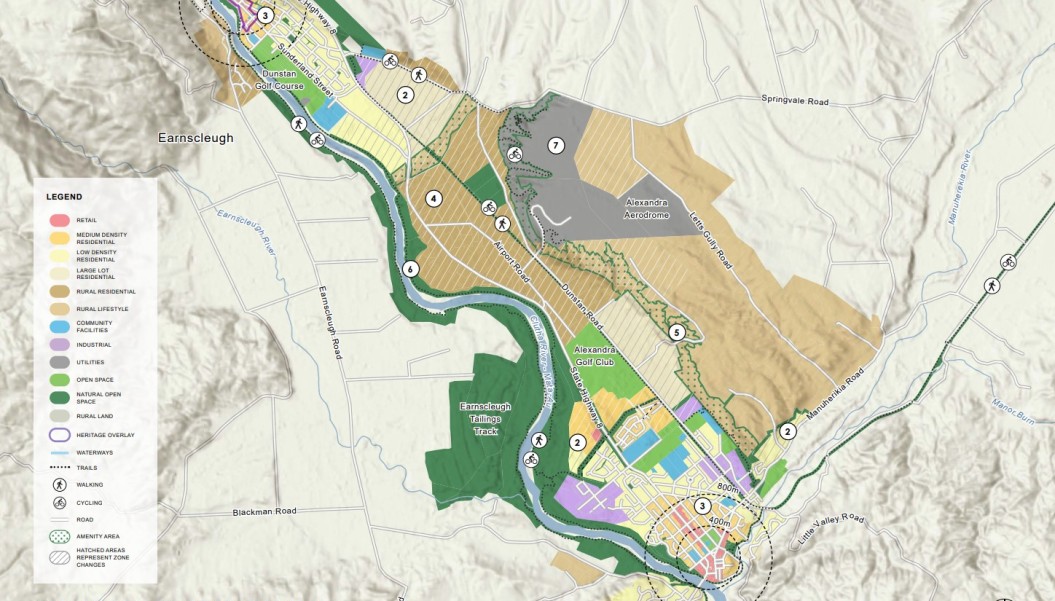
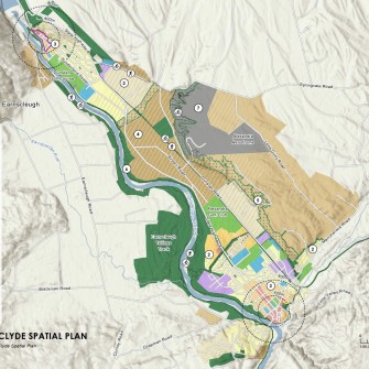
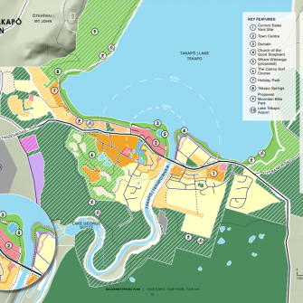
The Spatial Plan maps for Alexandra and Clyde townships represent a managed approach to growth over the next 30 years. They have been developed following feedback from the community and reflect community aspirations and considerations for growth and infrastructure through a mix of infill and new greenfield development within townships, and a modest expansion into existing lifestyle block areas.
The Spatial Plan for Omākau and Ophir sets out a framework for modest, consolidated growth. This plan was also shaped by community feedback and reflects community aspirations to support local businesses in Omākau, provide green accessways that connect the two towns, and retain Ophir’s heritage values. Future growth in Omākau and Ophir is constrained in the short term until upgrades are made to the water and wastewater services.
The Vincent Spatial Plan is already helping to shape future changes to the Central Otago District Plan. The first chapter of the Plan that is under review is residential section (i.e., areas within townships that are zoned for residential use).

LEARN MORE
- Read the final Vincent Spatial Plan (PDF, 15MB)


OUR PROJECTS WHAT WE DO
NZ DRIVER LICENSING IMPROVEMENT PROGRAMME
THE PROBLEM
More than one million people over 16 years who live in Aotearoa New Zealand currently do not have a…

CONSISTENT CONDITION DATA COLLECTION
The Te Ringa Maimoa Consistent Condition Data Collection (CCDC) project is a game changer for local road asset management in…

TE MANAWATAKI O TE PAPA
Tauranga’s city centre was failing to deliver the social, cultural, economic and environmental benefits expected of the fifth largest city…

SUPPORT THROUGH THREE WATERS UNCERTAINTY
Understanding how to fund the required investment in three waters is a significant challenge many local authorities are grappling with.
MACKENZIE DISTRICT PLAN REVIEW
Mackenzie District Council (MDC) is updating its District Plan to ensure the Mackenzie District can grow in a sustainable way,…
VINCENT SPATIAL PLAN
The Vincent area in Central Otago has an extraordinary and distinctive character.
WEST COAST COMBINED TRANSPORT PLANNING
Since 2017, Rationale has been working with the three Council’s on New Zealand’s West Coast (Te Tai o Poutini) as…
MACKENZIE SPATIAL PLANS
The Mackenzie District has been significantly impacted by unprecedented and sustained levels of growth over the past ten years.

THREE WATERS REFORM PLANNING BUSINESS CASE
Councils around the country are facing significant change and uncertainty in the three waters space, with significant government reform underway.

QUEENSTOWN TOWN CENTRE MASTERPLAN
The Queenstown Masterplan came about when a long period of under-investment in the town’s infrastructure inevitably collided with an ongoing…

KOPU MARINE PRECINCT BUSINESS CASE
The Thames Coromandel District is well known throughout New Zealand for its warm climate, beautiful beaches and bush-clad hills.

CORPORATE SERVICES FEASIBILITY STUDY
The Social Wellbeing Agency (SWA) is a central government organisation that supports social sector decision-makers, providing cross-social sector advice on…